
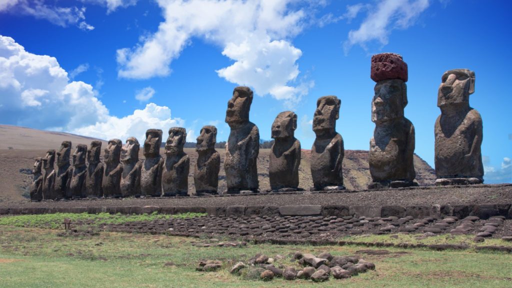
The fifteen moai of Ahu Tongariki. “Los 15 moais del ‘Ahu Tongariki’” by Carlos Reusser Monsalvez is licensed under public domain.
Easter Island has been called the world’s greatest open-air museum, and indeed the entire island can be seen as one huge archaeological site.
—John Flenley and Paul Bahn, The Enigmas of Easter Island
Everyone knows something about Easter Island, or Rapa Nui as it is called on the island. Rapa Nui National Park covers much of the island and is listed as a World Heritage Cultural Landscape. The island is remarkable just for the fact that it is inhabited at all. Easter Island, so named because it was encountered in 1722 by Dutch explorer Jacob Roggeveen on Easter Sunday, is located more than a thousand miles from any other landmass. What’s more, it’s one of the tiniest inhabited islands in the Pacific, a volcanic speck in the Pacific Ocean, just 66 square miles. The island contains more than 950 stone statues, called moai (mo-eye), about 50 of which were transported over long distances, and 150 ahu, the stone constructions that supported many of the moai. At least one moai has been exported from the island and others are likely buried and unknown to archaeologists.
The moai, which are thought to represent venerable ancestors, are massive heads with torsos made from volcanic tuff from the interior and exterior slopes of an ancient volcano called Ranu Raraku on the southeast side of the island. In their book, The Enigmas of Easter Island Flenley and Bahn write: “From the islander’s testimony and other Polynesian ethnography it is virtually certain that the statues represented high-ranking ancestors.” (p.109).
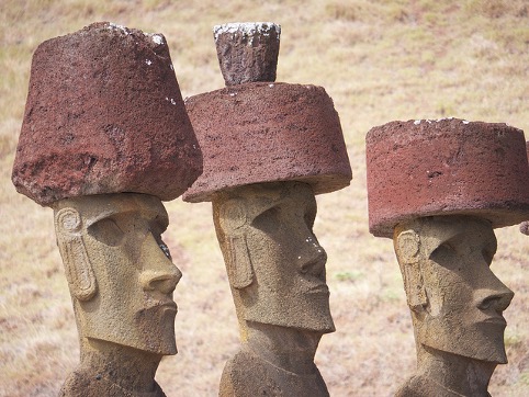
Standing moai range from 6 to 35 feet in height and weigh as much as 82 tons. The red top knots (pukao) that adorn some of the moai were made from red volcanic rock from Punapau Crater. The exteriors of the moai were originally smoothed, and sometimes carved, but are now mostly eroded. Some of the moai were installed on stone platforms called ahu. The moai were toppled for unknown reasons sometime after the initial European contact (post-1722), perhaps clan warfare, but re-installed in modern times.
Richards et al. 2011, p. 192 By Eric Gaba (Sting), translated by Bamse [CC-BY-SA-2.5
(http://creativecommons.org/licenses/by-sa/2.5)], via Wikimedia Commons
Where did they come from?
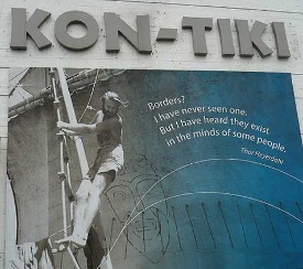
Norwegian adventurer Thor Heyerdahl (1914–2002) proposed an early idea about how Polynesia, in general, was colonized. Heyerdahl thought that the Polynesian islands were colonized by the indigenous inhabitants of South America, based on perceived similarities in watercraft, architecture, and oral history. He demonstrated the feasibility of traveling from South America to Polynesia by piloting a balsa wood raft from Callao, Peru to the island of Raoria in 1947—some 4,000 miles—which he describes in fascinating detail in Kon-Tiki. This was perhaps the most ambitious experimental archaeology ever conducted. Today there is even a museum dedicated to the journey in Oslo, Norway. Heyerdahl was interested in a story told by Rapanui about two peoples, “Long Ears” (or slim people) and “Short Ears” (or stocky people). Heyerdahl thought the Long Ears represented the original inhabitants from South America who arrived around AD 400 according to radiocarbon dates; These people, he supposed, were the ones who built the remarkable stone monuments. The Short Ears, he argued, were Polynesian interlopers who came sometime later and clashed with the Long Ears, effectively killing them off around 1680 along with their spectacular culture based on the moai. Today, the genetic, linguistic, and archaeological evidence does not support large-scale South American colonization. Though a recent study suggests that modern Rapanui have genetic overlaps with South Americans, analysis of prehistoric skeletons would be necessary to make a solid claim for South American colonists because the Rapanui were known to have traveled as slaves to South America, but returned to the island later. Future genetics could reveal a very different story of Easter Island. Critics of Heyerdahl have pointed to the absence of South American domesticates (maize, beans, squash), the lack of pottery, and the absence of pressure flaking techniques so common in the Americas. Many have noted that sailing craft like the one used by Heyerdahl did not exist until after European contact and also his watercraft was towed out fifty nautical miles before setting sail, avoiding a northward current. Other critics have been more scathing in their critique. Writer Paul Theroux quipped that the Kon-Tiki expedition showed that “sexy middle-class Scandinavians could successfully crash-land their craft on a coral atoll in the middle of nowhere”.
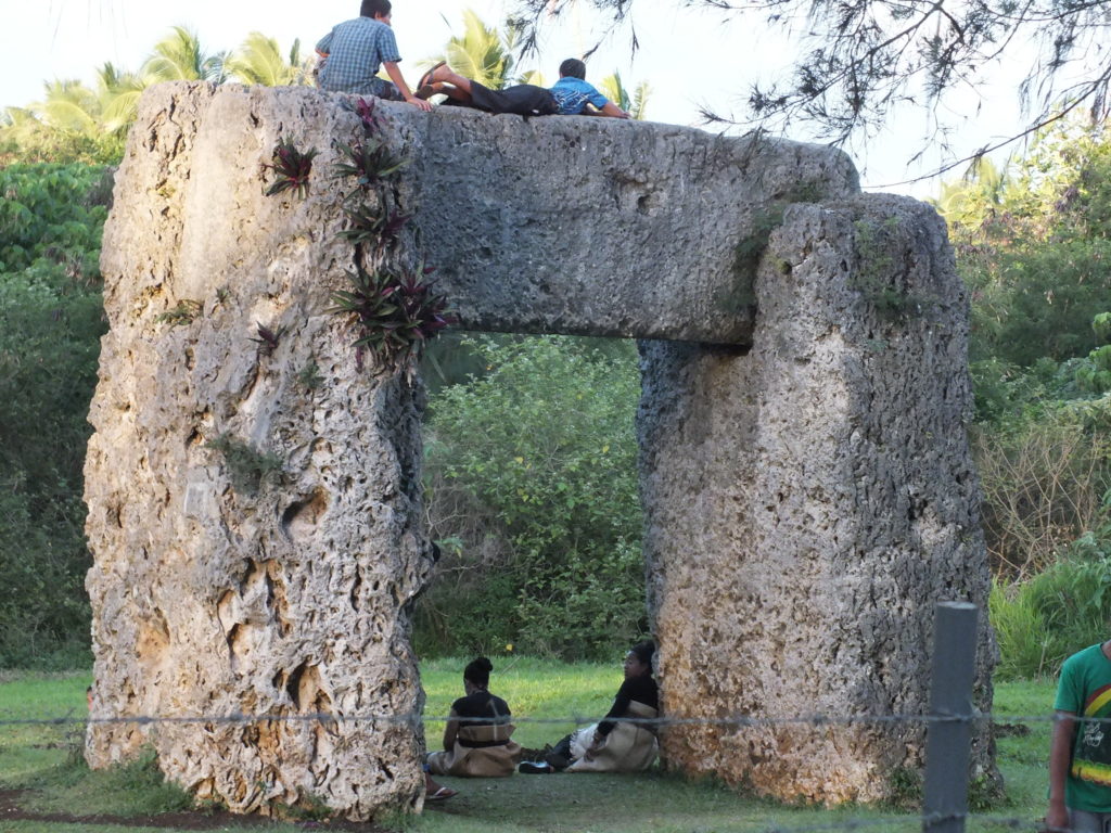
The island had the South American sweet potato and bottle gourd, so contact of some sort of contact is not out of the question, but certainly not demonstrated. There are parallels to Rapa Nui monuments elsewhere in the Pacific, so South American masons and hyper-diffusionism do not have to be invoked to explain the stone monuments on Rapa Nui. Shrines/ceremonial houses called marae on other Polynesian islands are similar to the ahu of Easter Island. Other Polynesian islands built monumental structures, such as the trilithon of Tonga or the Takaii of Hiva Oa. On nearby Pitcairn, the mutineers of the Bounty pushed stone statues installed on a platform off a cliff (the island was uninhabited when the mutineers landed there). Some have suggested that Polynesians contacted South Americans and not the other way around. Whatever the exact history of the colonization of Rapa Nui, Heyerdahl’s sailing exploits are legendary, though his ideas have not been substantiated.
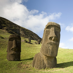
Ahu Nau Nau. Note the “long ears”. Flickr, Creative Commons. Photo: bmeabroad licensed under CC-BY 2.0.
Getting There
Polynesians were master sailors. Based on computer simulations, it would have been impossible to colonize the furthest reaches of Polynesia without a sail, though there are documented cases of rafts (without sails) drifting off course from islands. Moreover, it is thought that colonizing remote islands would have been a one-way affair, with no hope of returning home. The dating of Rapa Nui colonization is contentious. Early work by Heyerdahl suggested a date around A.D. 900. More recently, the dating of the earliest occupation has come into question. The early radiocarbon dates were from an unidentified sample of wood and are therefore questionable. There is a problem with dating wood samples that might be earlier than the human deposits. This is the old wood problem. Inner tree rings will radiocarbon date earlier than outer rings. More recent dates from excavation suggest the earliest occupation may have been much, much later—as late as A.D. 1200. Clearly, this is yet another mystery of Easter Island.
Island Devastation: Alternative Views
Rapa Nui was formed from volcanic seafloor eruptions and is today marked by rocky lava-covered terrain. There are no permanent streams or rivers, and water exists in the volcanic craters and springs. Three extinct volcanoes dominate the landscape. Today, Rapa Nui is a barren landscape, sometimes described as a moonscape. When explorers like Captain James Cook, landed on Rapa Nui, they noted the island’s limited resources and largely treeless terrain. Cook remarked, “Nature has been exceedingly sparing of her favors to this spot”. If you go to Google Earth and check out the images from other Polynesian islands, you can see why Cook and others would have been so unimpressed with Rapa Nui.
Studies of ancient pollen grains preserved in old lake bed sediments indicate environmental change over time. The study of pollen is called palynology and is useful in the reconstruction of ancient environments. Drilling down into the bed, one can get a core of accumulated sediments, including seeds, charcoal, and pollen. According to the pollen record, the island was once covered in palm forest, including a giant species with a trunk up to a meter in girth. Evidence of the roots of these giant palms is seen below the human occupation (recall the Principle of Superposition). Later, the forest pollen vanishes from the record and is replaced by grass. In addition, there is evidence of soil erosion and the use of smaller plant remains as opposed to wood.
One account of the failed environment comes from ornithologist and popular writer Jared Diamond. In this account, Diamond argues that the highly productive environment supported the great chiefdoms that built the moai. Forests were burned down to clear agricultural fields (slash-and-burn farming), or cut for fuel, canoes, or sleds to move statuary. The population of the island increased, and the greed of the chiefs in their drive to build more moai, which required wood, finally overtaxed the environment. In short, it was a kind of ecocide. Statues in progress were abruptly abandoned in the quarries and along
transport routes. Civil war and even cannibalism ensued, and the statuary was toppled by rival groups.
Rats!
An alternative view to the ecocide hypothesis was recently proposed in a book by Terry Hunt and Carl Lipo called The Statues that Walked. The authors radiocarbon-dated the arrival of people to the island at A.D. 1200. They point to other studies that show the disappearance of most of the island’s wood by 1650, after which people began to burn grass, ferns, and other plant material for fuel.
Hunt and Lipo’s explanation for the environmental change was altogether different than Diamond’s. In colonizing islands, Polynesians often brought dogs, pigs, chickens, and rats with them to use as a food source. To understand their argument, it is necessary to look at another Pacific Island, Hawai’i. Polynesian researcher, Steve Athens, studied the deforestation of Hawai’i which lost most of its native forest by 1500. Lakebed pollen cores 26 feet thick showed that the decline began around 1200 in Hawaii, soon after people landed on its shores. Yet, deforestation appeared to precede human-caused fires. In addition, many native birds had begun to go extinct. In a total plot twist, Athens, a former UNM graduate student, blamed the Polynesian rats for the destruction. Rats, who had traveled to the island with humans, had occupied parts of the island that humans had not yet occupied. The sediment cores were also full of rat bones. At the same time rat remains showed up in the core sediments, there was also evidence for forest decline and the birds became less prevalent. Essentially, the rat was seen at the scene of the crime, but not humans.
Ecologists have shown that rats can devastate an environment, voraciously feeding on nuts such that new trees do not regenerate and leaving little for bird populations. On Lord Howe Island, a natural UNESCO Cultural Landscape due to its unique plant and animal communities were infested with black rats when a steamship ran off-course on the island. The rats have been implicated in the loss of birds, invertebrates, and plants. Hunt and Lipo argue that a similar “plague of rats” contributed to the decline and ultimate demise of the Rapa Nui forests.
As with the Hawaii sediments cores, Hunt and Lipo found an abundance of rat bones in their excavations of cultural remains. Documents of the Cook expedition of 1774 also indicated that Rapanui ate rats. Hunt and Lipo concede that palms were also cleared and burned for agricultural purposes, but this, they argue, was not what devastated the landscape, ruining the island paradise. Rather, they argue that soils on Rapa Nui were always poor and that the Polynesian colonists made the most out of the resources they had. The story of Rapa Nui, they claim, is not one of human ecocide but of persistence and resilience in which the islanders employed innovative approaches and a willingness to invest massive amounts of labor. Hunt and Lipo write, “Rather than a case of abject failure, Rapa Nui is an unlikely story of success.”
It is easy to draw moral conclusions from the archaeological record. On the one hand, Rapa Nui’s environmental decline can be used as a cautionary tale about extravagant use of sparse resources. Or the record can be used to celebrate human ingenuity in the face of a difficult environmental situation. Whatever the truth, archaeologists need to recognize how these potential biases might color one’s approach to the past. We have to at least be aware of how our own motivation and current environmental concerns might affect our thinking.
Farming Ingenuity
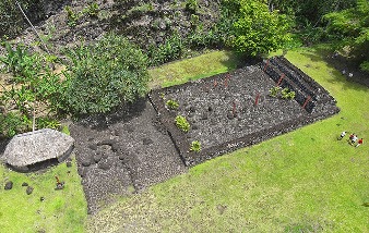
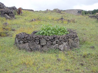
Rapa Nui is a wonder for its monuments, for the fact the people found it at all, and that people managed to grow anything. The soils are notoriously poor. The Rapanui had ingenious farming techniques. Small circular enclosures with high walls made of a rock called manavai protected the fragile plants from the elements. The soils inside the features were much richer than those outside of them, indicating they were enriched with organics. These features have been located, using satellite images and ground-truthing, walking the landscape to verify features found on the satellite images. More than 2,500 of these features were found within a mile of the coast of the island. In other areas of the island, other techniques were used to increase the productivity of the soil. Graduate student Joan Wozniak surveyed, and walked the landscape systematically, other parts of the island, finding nothing but a field of rocks. Excavations, however, revealed stone tools, pits, and broken rock. She also noticed modern farmers on Rapa Nui placing rocks around their plants. Based on these findings she suggested that the inhabitants of Easter Island practiced “lithic mulching”, or placing rocks around a plant to improve the temperature and nutrient leaching from the rocks. Where earlier explorers and researchers had seen a barren rocky landscape, this keen-eyed student had seen an ingenious agricultural trick that got the most of the soil conditions. Given the vast stretches of rock on the island, the people of Rapa Nui were busy moving rocks, and a lot of them.
The Moai
Some moai are positioned on stone “stands” called ahu facing inward to the island. Some, but not all had red pukao resting on their heads. These additions might have represented hair or headdresses of authority. Indeed, islanders were very interested in European-style hats and many were swiped off the heads of sailors never to be seen again. An early account suggests these moai were important parts of ancestor veneration rituals. We learned in the last chapter that ancestor veneration is often important to farming societies.

Dutch explorer Roggeveen related, “What form of worship of these people comprises we were not to gather any full knowledge of, owing to the shortness of our stay among them. We noticed only that they kindle a fire in front of certain remarkably tall stone figures they set up; and after squatting on their heels with heads bowed, they bring the palms of their hands together and alternatively raise and lower them.” (p. 118). Many ahu have canoe-shaped bases, and the front ramp of the ahu is covered with poro or smooth sea boulders. In front of the ahu complex is a plaza, perhaps an area for ceremonies. Crematoria, an area for human cremations, are located on the seaward side of the ahu. Installing the ancestral figures at the edge of land and sea is consistent with the Polynesian concept that after death the soul travels westward to the sea to the point of origin.
Other moai are not housed on ahu, but rather are located in and around the quarry Rano Raraku. There, hundreds of volcanic moai are located. The volcano is comprised of distinct bays that have their own individual style of quarrying. The Rapanui used harder basalt axes called Toki (check them out here) to carve the relatively soft tuff, and hundreds of them appear in the quarry. Ax marks can be seen on the quarry walls. Erich Von Daniken, who thought the Maya king Lord Pascal was piloting a spacecraft (we’ll discuss this later), did not think it possible that the Rapanui could carve the moai without modern equipment. And yet the tools and evidence are everywhere. In Polynesia’s cosmology (world-view) volcanoes are important conduits between this world and the interior world. As such, the volcanic quarries may have had symbolic meaning in addition to supplying suitable stone for working into moai and pukao as well as freshwater. On other Polynesian islands, volcanoes are thought to be both living and self-replenishing. Eye sockets carved into quarry bays at Rapa Nui suggest the possibility that these areas were conceived of as living entities. The relative size of the largest standing moai is called Paro.

Partially completed moai reveal the stages of carving. The largest moai ever carved, El Gigante (65 feet, ca. 260 tons), lies at Ranu Raraku unfinished. The carvers began the giant sculptures in both vertically and horizontally oriented stone. Faces appear out of the rock with the bodies unfinished, indicating that the carvers started with the facial features first then completed the head, then the body. Stone was chipped away from all but a single keel attaching it to the rock face. Some of the moai at the quarry are partially buried. One school of thought claims that the moai, once extricated from the quarry, were then slid down to the base of the volcano into trenches where they could be worked further. Others think they were installed there permanently. These “heads” are not in fact just heads. These quarry moai, like the ones installed on the coastal ahu, have full bodies
that appear to have been buried naturally. Recent excavations by Joann Van Tilburg show that carvings still remain on these moai, preserved in the sediment. Though some think that moai were installed permanently on the slopes of the quarry, others believe that when completed, all moai were intended to make their journey along roads to the sea to be installed on an ahu facing landward. There on the ahu, the eye sockets would be added along with the coral irises, obsidian or red volcanic pupils, and back carvings that might have represented tattoos.
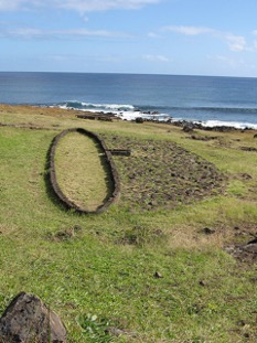
The ahu are stone platforms that support the installed coastal moai. These were made by building the interior foundation and filling it with rubble. In some cases, as at Ahu Vinapu, massive blocks of basalt were cut to fit snugly together. This tightly fitting masonry is sometimes cited as evidence of South American origin, being similar to South American masonry. Unlike South American masonry, however, the interior stones are not snugly fit.

The contrast between the stark environment of Rapa Nui and the colossal sculptures has led people to suppose that the indigenous populations could not have managed the feat. Wilds ideas, like moai being catapulted out of volcanoes, have been offered up instead. Yet, moai roads have been reported since Cook’s expedition and documented in more detail by Katherine Routledge in the early 1900s. Remnants of these moai roads have been recently recorded using detailed satellite imagery and ground truthing. Of course, parts of the road system have been obliterated by modern use or converted into horse trails and modern roads. Yet, the roads extend out of known quarries like Rana Raraku and lead down to the coast. The roads were intentionally raised in places and depressed in others to level the slope.
Moai on the Move
Two general competing ideas have been put forth to explain how the moai were moved from their quarries to the seaside: horizontally and vertically. Experimentation shows that with A-frame sleds, it is possible to slide moai with about 40 or so people. Getting the moai to its ahu in a horizontal position requires the use of levered sleds. In short, it can be done. Thor Heyerdahl tested the horizontal hypothesis through experimentation in the 1950s. Rapanui insist that the moai “walked” to their current positions. In 1986, Czech engineer Pavel Pavel seriously considered the “walking moai” idea and concocted a 12-ton cement moai with ropes attached, and with the help of 16 men, managed to move the moai, tilting it back and forth in the way one might move a refrigerator. Heyerdahl invited Pavel to come to Easter Island to try his idea out on real moai, which he did. It worked. The moai were walking, just like the natives said they could. As it turned out the natives even had a word, neke neke, for the motion the statues took while walking, which translates into “walking without legs”.
Indigenous archaeologist Sergio Rapu pointed out that the moai of the quarries are shaped differently than the moai installed on the seaside ahu. They were wide at the base with big bellies with a low center of mass, as well as angled to lean slightly forward. The moai on the ahu was considerably pared down. Rapu proposed that the moai were “engineered to move”. (i, p. 87) following Rapu’s insight, Hunt and Lipo conducted a similar archaeological experiment to Pavel’s with some adjustments, also showing that the moai could move vertically. Hunt and Lipo are of the school that the moai were all intended to be installed on ahu, some of which made it, some of which did not. They point out that more than 50 moai were abandoned along the roadway, facing away from the quarry and aligned with the direction of the road. The breakage of moai also suggested to them that they broke during transport with some force. When the moai were moving upslope, they tended to be on their back, and downslope on their fronts. Moreover, they find wear on the base of the moai that they argue is consistent with vertical movement. Finally, they suggest that no wooden apparatus was needed, and indeed palm would have been ineffective, being crushed by the weight of the moai.
Moai as Boundary Markers
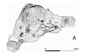
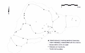
Others reject the idea that moai were abandoned along roadways on their way to the ahu, but rather served to mark territorial boundaries or were stationed along roads for symbolic purposes. The coastal moais installed on ahu are thought to represent the coastal boundaries of territories. Early ethnography indicated the existence of territorial boundaries based on the lineages of the original founder of the island Hotu Matua. Using Geographic Information Systems (GIS), a mapping program, a group of researchers mapped out the interior moai and overlaid these on top of the early recorded territorial boundaries. GIS has become an enormously important technology in archaeology, allowing archaeologists to compare all kinds of datasets—soils, terrain, roads—with the material record. The authors found that moai not associated with roads corresponded well with ethnographic (historically recorded) territorial boundaries. Large stones that appear near these fallen moai may have served as platforms. Also, erosional patterns suggest that these may have stood for some time before falling. Some scholars have suggested the moai may have been used as a kind of competitive display between territories. The moai may have embodied mana, the pan-Polynesian idea in which nobility contains a powerful life force. The mana emanating from the statues could have served to protect the village and territory, perhaps not so different from Neolithic ancestor veneration in the Near East. Today, there is still a royal lineage on Rapa Nui, the Miru, who are the descendants of the island’s founder Hotu Matu’a.
Island Life
As we will see, like the Maya temples and Chaco Canyon great houses, the early research emphasis of Easter Island was the monuments—the moai. Less was known about how people lived their daily lives. Early accounts indicate that houses were mainly for sleeping and that many activities took place outside the house. Flenley and Bahn write that the elite houses were closer to the coast and more humble ones further inland. They argue that hare paenga, canoe-shaped houses with an outlined basalt stone foundation were high-status dwellings, as was thought by early Spanish explorers. Hare paenga are found close to platforms. Hunt and Lipo argue that these were merely communal houses and find no evidence for social rank. Near houses are ovens called umu pae, a stone-lined earth oven. Manavai are garden enclosures designed to protect gardens from the wind as well as provide additional shade and water. Hare moa (see image) were apparently ossuaries, places to house human bone, but were later used as stone chicken houses. Skulls from the royal clan were thought to increase egg yields. Food remains include dolphin bone, palm nuts, squash, fish, shellfish, chicken, and rats. Since Rapa Nui has no extensive reef, fishing seems to have been less important compared to other Polynesian islands. Human leg bone fish hooks are known. Flenley and Bahn suggest that the northwest portion of the island specialized in fishing, which was a high-status food, while the southeast was mainly dedicated to cultivation.
Egg Dash
At Orongo at the southwestern tip of the island, there was a ceremony practiced in historical times. Young male candidates were nominated by warlords from different tribes. Taking place in September, the object was for the young men to travel from the 1,000- foot sheer cliff off the Volcano Rano Kau into the ocean and swim through shark-infested water on reeds, to the islet Motu Nui. There, each man would have to find the brown-speckled egg of the sooty tern and carry it back to his warlord host in his headband. The warlord then became the new sacred birdman, Makemake’s (god) representative on Earth. The birdman’s group had access to the eggs on the island or in later years other privileges. By 1878, the ceremony became a test of skill and had no ritual or political meaning. Numerous birdman petroglyphs (473 on the entire island) occur in the area of Orongo along with ceremonial dwellings. One of these contained an unusual basalt moai, partially buried. The moai, Hoa Hakanana’i (Stolen Friend) was later taken to the British Museum (and later laser scanned for a 3D model). Ethnologist Katherine Routledge recorded a list of 86 sacred birdmen.
Commons. Photo: Eduardo Llanquileo
Disease
The island was contacted several times beginning in 1722 by the Dutch, then by the Spanish in 1770, Cook in 1774, the French in 1786. Rapanui were captivated with the boats, metal, and for some reason, the hats, of the Europeans. They measured the boats using string devices, impressed it seemed with the length of the wooden planks used. In some cases, the Europeans used muskets against the Rapanui who were prone to swiping cloth and hats from the Europeans. As with the Inca, the Rapa Nui had no immunity to Old World zoonotic diseases. Recall that zoonotic diseases are ones that first began in animals, then “jumped species” to humans. People in the Old World had a greater tolerance for the disease, while the newly contacted people had none, with devastating effects. Since Native Americans, Australians, and Polynesians had few domesticated animals, the devastation by zoonotic disease was a one-way phenomenon. Venereal disease likely also took hold on the island, as there are explicit accounts of sexual encounters between European men and Rapanui women. While early explorers indicated thousands of people on the island, Cook’s expedition reported 600–700 people. Following the Cook expedition, whalers came to the island sporadically, sometimes kidnapping both men and women, creating hostility between the islanders and foreign ships. Later, Peruvians came to the island and indentured more than 1,000 Rapanui to work in guano (bird feces) mines and other forms of servitude. By 1877 the island had just 110 people left. In 1896 most of the island was purchased by a Chilean merchant who set up a sheep farm, further devastating the island, causing the extinction of native plants and erosion.
With the arrival of Thor Heyerdahl in 1955, things began to change for the island, as it became a tourist destination because of the moai, helping the economy. Eventually, in 1966, the islanders gained full Chilean citizenship with an indigenous governor who is also an archaeologist, Sergio Rapu. Yet, the tourist trade is causing its own problems, as it tries to maintain an infrastructure to support it. In 2012, the island was visited by about 70,000 tourists. Landfills, sewage, groceries have all become a problem with the renewed interest in the island. The island is heavily reliant on supplies from the mainland.