
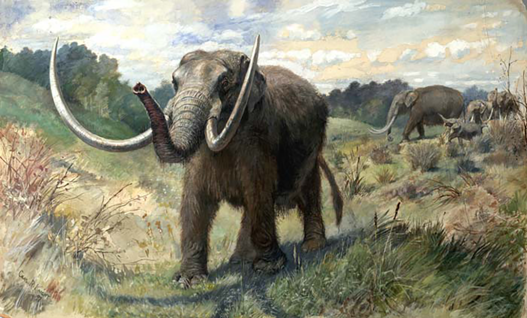
Artwork by Charles R. Knight
An understanding of New Mexico’s environment and climate is also vital to a full comprehension of its histories. Climate and topography help to explain the reasons for the area’s relative isolation. When the first people arrived in the present-day U.S.-Mexico border region about 11,000 BCE, it looked quite different. Megafauna, including mammoths, sloths, and other large animals, roamed the landscape which was much cooler and wetter than it is today. In more recent history, New Mexico’s aridity has become its defining climatic feature. Although the environment was quite different, however, it still influenced the types of decisions that the region’s First Peoples made about where and how to live. Such patterns were not unique to New Mexico; the earliest civilizations of the Fertile Crescent, for example, also based their patterns of life on the resources and conditions available to them.
By about 9,500 BCE, sweeping patterns of climate change transformed New Mexico and the surrounding region. It became much drier and hotter, more like the types of conditions that are present today. Human beings were forced to make difficult decisions about how to adapt to their altered surroundings. Most responded by hunting smaller game and gathering different types of plants for food. They also sought out sources of water, principally along the Rio Grande corridor, but also along other regional rivers, such as the Canadian, Colorado, Conchos, Gila, Pecos, Salt, and San Juan. Other factors, including rainfall, landscapes, altitude, and temperature, influenced the way people lived.
Narrowing our view to the present-day boundaries of the state, New Mexico is divided into six geologic and climatic provinces: Southern Rocky Mountains, Colorado Plateau, Rio Grande Rift, Basin and Range, Mogollon-Datil, and High Plains.
The Southern Rocky Mountain zone includes the Sangre de Cristo, Sierra Nacimiento, and Tusas mountain chains in the north central section of the state. The Colorado Plateau encompasses New Mexico’s northwestern corner, as well as portions of northeastern Arizona, southeastern Utah, and southwestern Colorado. It is defined by sedimentary rock forms that have been shaped into mesas and buttes by water erosion over long centuries. At the point where the Colorado Plateau pulls away from the High Plains is the Rio Grande Rift. Cutting through the center of the state on a north-south axis, the rift defines the course of the Rio Grande and contains vital aquifers that provide water to some of New Mexico’s largest population centers. Volcanic fields define the Mogollon-Datil province in southwestern New Mexico. The Organ Mountains near Las Cruces were the oldest volcanic eruptions in the 40,000-kilometer geologic area that also includes the Gila Wilderness. The High Plains region comprises the eastern third of the state. Dubbed the llano estacado (staked plains) by Spanish colonists, the area is an extension of the Great Plains and it contains some of the flattest land on earth. Finally, the basin and range province, defined by mountain ranges separated by dry valleys, comprises New Mexico’s “boot heel.” It is part of a much larger physiographic province that characterizes much of the American west and northern Mexico. Although the New Mexico Bureau of Geology and Mineral Resources describes the Rio Grande Rift as separate from New Mexico’s Basin and Range topography, other geologists lump the two together.
These varied landscapes reflect the seemingly stark choices that faced (and face) New Mexico’s inhabitants. At times, the rugged land and weather have forced entire groups of people to migrate to another part of the region, or to leave altogether. New Mexico’s aridity places the question of water availability at the top of the list of climatic considerations. The wettest parts of the state include the Sangre de Cristo Mountains in the north, which receive about forty inches of annual precipitation. Eastern plains and western plateaus typically receive moderate rainfall levels, between twelve and seventeen inches per year. The driest parts of the state, however, including the Rio Grande Valley, receive less than ten inches of annual moisture.
Fortunately, most precipitation arrives during the June-September growing season. The rest comes during the winter months. Spring runoff from winter snowpack fills the region’s rivers and streams, providing water to the valleys below. Although New Mexico’s rivers provide life-giving irrigation waters, they have proven to be fickle allies. Historically, late-spring flooding of the Pecos or San Juan Rivers has spelled disaster for young crops. The Rio Grande, still known as the Rio Bravo del Norte (literally translated “wild river of the north”) in Mexico and Latin America, has changed its course numerous times in New Mexico’s past. The region’s rivers were (and are) too shallow and unpredictable to be easily navigable; they could not serve as channels for communication and transportation. Such factors have contributed to New Mexico’s isolation, and they have shaped the types and sizes of societies that have evolved in the region.